Community-led Heritage Mapping in Kathmandu (Nepal)
4 min read
Guest author: Olga Chepelianskaia (UNICITI)
Editor's note: This piece is the first in a series of three posts entitled 'Mapping - a tool for urban resilience' which reviews varied uses of mapping from across the globe. The series specifically addresses: i) heritage in the built environment; ii) environmental management; and iii) cognitive maps for neighbourhood planning. The posts provide much-needed insight in complement to existing posts on the YA blog about various mapping methods. This first post introduces the series and focuses on community-led heritage mapping.
Mapping: a tool to build urban resilience
Post pandemic and disaster relief efforts have heavily relied on maps and surveys in the past. The global COVID outbreak map by Johns Hopkins University is keeping minute by minute tabs on the pandemic. Governments and health agencies are consulting them to track the situation and take action.
Mapping is also pivotal in providing humanitarian relief to disaster-affected communities. In the wake of the 2010 Haiti earthquake, crowdsourced platform OpenStreetMap along with Crisis Commons volunteers used available satellite imagery to map roads, buildings and refugee camps of Port-au-Prince in only 2 days, building the most complete digital map of Haiti's roads. Surely, mapping plays a crucial role in mitigating the effects of disasters.
With this background, today UNICITI reflects on the role of mapping in building resilience in cities of the Global South. The 3 chosen case studies each highlight the role of communities, planners and experts in mapping heritage, resources, and settlements.
Community led heritage mapping – Kathmandu, Nepal
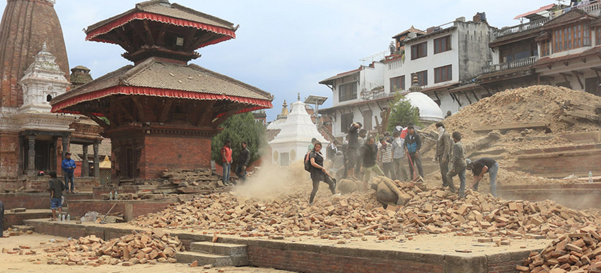
Nepal's tourism sector which supports 1.05 million jobs yearly was severely impacted due to the 2015 Gorkha earthquake. Source: UN News
The 2015 Gorkha 7.8 magnitude earthquake heavily impacted Nepal’s heritage structures. As per UNESCO, it affected nearly 2,900 heritage structures in Kathmandu, Nepal Valley and the North-Western region of Nepal. About 700 structures were damaged, among which 131 were destroyed.
This loss of cultural heritage at such a scale is dramatic for a country in which heritage driven tourism substantially contributes to the national economy. In 2018, Nepal's tourism sector supported 1.05 million jobs (Prasain, 2019). Unfortunately, while reconstruction took place rapidly with 83% of structures already reconstructed (National Reconstruction Authority of Nepal), the quality of the restoration works remains a big challenge. One of the major reasons for it was a severe lack of documentation on damaged heritage structures (The Nepal Heritage Documentation Project, 2020). In the case of the Notre-Dame Cathedral, the situation was different. Professor Andrew Tallon of the Vassar College Art History developed a detailed laser-scanned model of the cathedral before the fire took place. Today, conservation architects have access to precise data on the geometry, materials, details and construction techniques that were used in the damaged part of the structure.
Digital heritage documentation can indeed go well beyond conventional on-paper documentation. Heritage layers are documented with high precision and can greatly help reconstruction. In addition, active elements can be added as well – for example, candles burning in a prayer room or the sound of monks’ chants in a monastery – and create a more engaging virtual heritage experience.
Nepal realized the value of digital heritage documentation too. Kathmandu’s first geo-crowdsourcing system Share Our Cultural Heritage – SOCH – is revolutionizing heritage documentation and monitoring efforts. Initiated by Newcastle University, UK in 2017, the platform helps georeference cultural heritage data such as oral history, locations and images. It uses photogrammetric modelling to reconstruct heritage structures or artefacts into 3D digital models. These are then visualized on an open-access website or mobile app. Such a system is affordable because it catalyses crowdsourced inputs and is effective because it digitises detailed information about the structures.
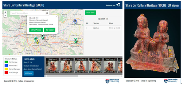
SOCH platform by Newcastle
University. Source: SOCH Platform
Let’s have a deeper look into the process:
Step 1 - Photogrammetric documentation. Photogrammetry is the method of photographing heritage structures in detail and transforming them into digital models. These models inform on the geometry, materials and different layers of repair of the structure with great accuracy. The final model is achieved by using a combination of softwares. Agisoft Metashape was used for photogrammetry along with MeshLab for refining the models. Tinkercad, and Blender helped create the final 3D model Importantly, all these softwares are open source.
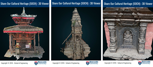
Examples of Nepalese heritage structures and 3D models created using SOCH Source: Dhonju, Xiao, Mills, and Sarhosis (2018).International Journal of Geo-Information.
Step 2 - Capacity building. In 2018, the University of North Carolina organised a 5-day workshop in Kathmandu. It added to the initiative by teaching the basics of photogrammetry and VR modelling. Participants were to bring their own SLR cameras and laptops, on which they could learn image capture and 3D model creation techniques.
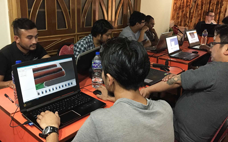
Digital modelling of cultural heritage in Kathmandu, Nepal
Source: Lenovo.com
Step 3 - Sharing the experience: The models documented during the workshop were shared through virtual reality headsets. This model goes beyond conservation: it lets global heritage enthusiasts indulge in this remote active heritage experience. SOCH platform offers a window into how people interact and own their culture. This is a huge step in retaining the living heritage.
Links for further reading:
https://news.lenovo.com/rendering-nepals-sacred-sites-in-stunning-3d/http://dro.dur.ac.uk/27713/1/27713.pdfhttps://www.researchgate.net/publication/327356394_Share_Our_Cultural_Heritage_SOCH_Worldwide_3D_Heritage_Reconstruction_and_Visualization_via_Web_and_Mobile_GIS
Biography

Olga Chepelianskaia is principal consultant and founder at UNICITI. Olga has international technical field experience in over 20 Asian cities and 40 Asian countries, conducted in the frame of programs and projects implemented for a number of international development institutions such as the ADB, CDIA, UNECE, UNEP, UN ESCAP or UNDP.
When you subscribe to the blog, we will send you an e-mail when there are new updates on the site so you wouldn't miss them.
Comments 3
[…] ← Community-led Heritage Mapping in Kathmandu (Nepal) […]
[…] series of entitled ‘Mapping – a tool to build urban resilience’ (see post 1 about community-led heritage mapping, and post 2 about environmental resources mapping for sustainable agriculture). This post […]
[…] Community-led heritage mapping in Kathmandu (Nepal) by Olga Chepelianskaia […]