The Earth has an average planetary albedo of ∽0.3 (Wielicki, Wong, Loeb, Minnis, Priestley, & Kandel, 2005), but considerable differences exist between different areas on the planet. Figure 1 shows that different areas on Earth are characterized by different surface albedos. The highest albedo is reached in areas covered by snow or ice or where there is a high concentration of clouds or both clouds and snow. The white shows the areas characterized by the highest albedo and that, consequently, reflect the highest percentage of shortwave solar radiation. Besides, the lowest albedo, represented in figure 1 with the dark colors, characterizes regions with low albedo that, as a consequence, reflect a reduced amount of solar radiation. This occurs in open-ocean, where the shortwave radiation penetrates the water, and in forest-cover landscapes.
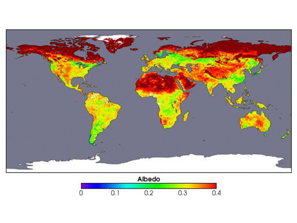 Figure 1 Image courtesy Crystal Schaaf, Boston University, based upon data processed by the MODIS Land Science Team (Source: http://visibleearth.nasa.gov).
Any significant change in land albedo, cloud cover, aerosol or atmosphere affects the reflected amount of sunlight which, in turn, influences the climate system. Broadly speaking, a decrease of 0.01 in Earth’s albedo would cause Earth to retain additional 3.4W/m2 and would have the same impact of doubling the amount of carbon dioxide in the atmosphere (Wielicki, Wong, Loeb, Minnis, Priestley, & Kandel, 2005).
The surface albedo modification can be driven by both natural and artificial causes. For example, in 1991, the atmospheric aerosol due to the eruption of the Mount Pinatubo provoked an increase in the global albedo by 0.007, that, in turn, caused an increase of the solar radiation reflected (i.e., 2.5W/m2) for the following two years. However, apart from the specific land albedo, also latitude plays a crucial role in the amount of solar radiation that is scattered back to space, in fact the higher is the latitude, the lower is the incoming solar radiation (i.e., the insolation rate is higher near the equator than to the poles) (see Figure 2).
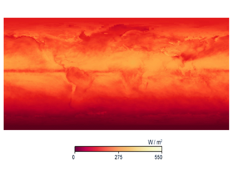
Figure 2 Solar insolation for the month April 2010. Image by Jesse Allen, NASA Earth Observatory, based on FLASHFlux data (Source: http://neo.sci.gsfc.nasa.gov)
The false-color map (figure 3) shows the amount of net radiation – expressed in W/m2 – recorded in April 2010. Comparing figure 1 and figure 3, it can be easily observed a correspondence between the surface albedo and the amount of net radiation at a given time. The regions of positive net radiation have an energy surplus, and the areas of negative net radiation have an energy deficit. The map illustrates the fundamental imbalance between net radiation surpluses at the equator (red areas), where sunlight is direct year-round, and net radiation deficits at high latitudes, where direct sunlight is seasonal (blue areas). This imbalance is the fundamental force that drives atmospheric and oceanic circulation patterns.
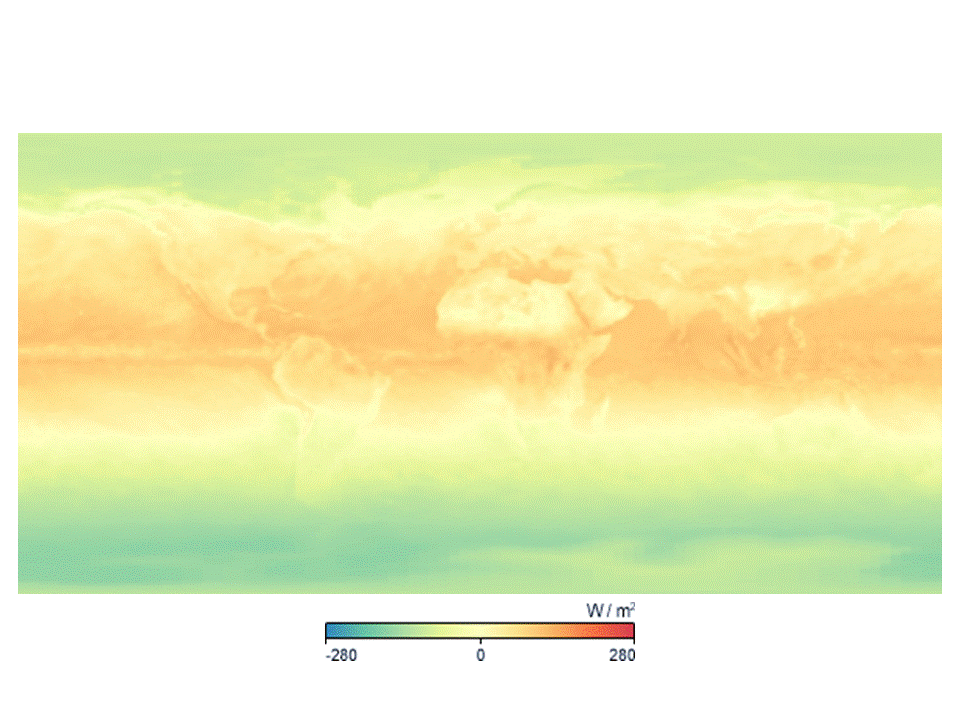 Figure 3 April 2010 Net Radiation. Image by Jesse Allen, NASA Earth Observatory, based on FLASHFlux data (Source: http://neo.sci.gsfc.nasa.gov)
Climate geo-engineering, defined as the large-scale engineering of the environment, aims to modify the Earth’s radiative imbalance, increasing the amount of outgoing shortwave radiation or the emitted long-wave radiation in order to counteract the effects of the changes in atmospheric chemistry such as the increase in greenhouse gases (NAS, 1992). Nowadays, we are constantly involved in a project of inadvertent geo-engineering. For instance, human beings affect Earth albedo acting on urban territory. Because of the increasing migration towards cities, the urban territory is experiencing an urban sprawl, especially in developing countries. Indeed, as it can be noted in figure 4, the most densely populated areas, in bright red, are in China, India, Europe and North America. Especially for the developing countries the growing cities can affect both the regional albedo and the local one. In the urban environment, the use of artificial materials – such as asphalt – with a lower albedo than natural materials, reduces the amount of radiation that is scattered back to space and increases the amount of long-wave radiation that remains in the Earth system, giving rise to local/regional and urban climate warming.
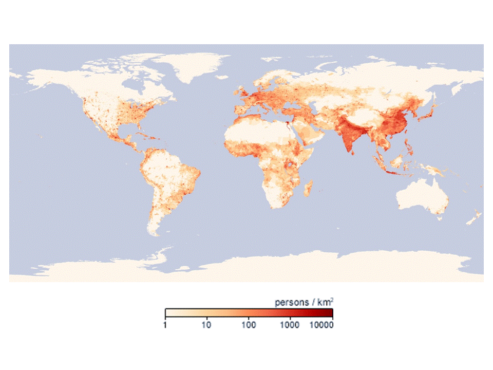
Figure 4 Population density in the period January 1st 2000 – December 31st 2000. Image by Robert Simmon, NASA's Earth Observatory, based on data provided by the Socioeconomic Data and Applications Center (SEDAC), Columbia University (Source: http://neo.sci.gsfc.nasa.gov)
Therefore, it is straightforward to understand that surfaces with different albedo can differently affect climate. Until some years ago this consideration was not included in life cycle assessment (LCA). Thus, surfaces with low and high albedo were considered as having the same impacts. A recent strand of research shows the importance of including the evaluation of the effects of surface albedo on climate in LCA.
In the following, as an example, an average equivalence between the change in surface albedo and carbon dioxide equivalents has been proposed. In particular, it has been roughly evaluated the impact deriving by the substitution of 1m2 of natural surface (characterized by the mean biome’s albedo for the period April 2010) with 1m2 of black roof (albedo: 0.05). The map shows that depending on the initial albedo of the biome and depending on the latitude, 1m2 of black surface can have a different scale of impacts on climate.
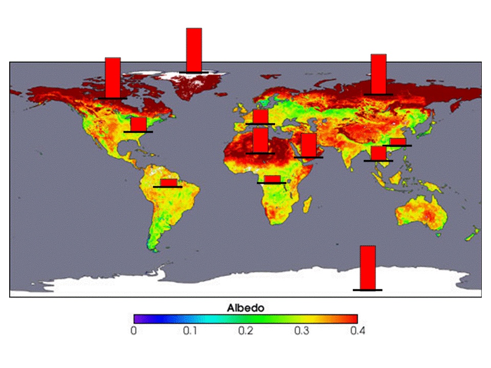
Figure 5 Impact of the surface albedo of one square meter of black roof when compared with the average area albedo (Source: modified Crystal Schaaf, Boston University image)
The Akbari model (Akbari, Menon, & Rosenfeld, 2009) has been used for evaluating the CO2 equivalence deriving by the substitution of 1m2 of natural surface with 1m2 of black roof. The bar graph shows that the black roof has the highest impact at the polar caps, where the surface albedo, due to the permanent ice, is constantly about 0.9. In tundra the impacts are also very high (surface albedo 0.8) as well as in the desert areas where the sand albedo is about 0.5.
It is worth underlining that the above map aims just to show a recent approach to the application of LCA in which the local environment is taken into account, but more comprehensive evaluations can be conducted including further parameters.
References:
Akbari, H., Menon, S., & Rosenfeld, A. (2009). Global cooling: increasing world-wide urban albedos to offset CO2. Climatic Change, 94, 275-286
NAS. (1992). Policy Implications of Greenhouse Warming: Mitigation,Adaptation, and the Science Base. Washington D.C.
Wielicki, B. A., Wong, T., Loeb, N., Minnis, P., Priestley, K., & Kandel, R. (2005). Changes in Earth’s Albedo Measured by Satellite. Science, 308, 825
Further readings:
Susca, T., et al., (2011). Positive Effects of Vegetation: Urban Heat Island and Green Roofs. Environmental Pollution, 159 (8-9), 2119–2126
Susca, T., (2012). Enhancement of life cycle assessment (LCA) methodology to include the effect of surface albedo on climate change: Comparing black and white roofs. Environmental Pollution, 163, 48–54
Susca, T., (2012). Multi-scale approach to the life cycle assessment: Evaluation of the effect of the New York City increase in rooftop albedo on human health. Journal of Industrial Ecology, 16 (6), 951–962
*Rearranged text from:
Susca, T. (2011). Evaluation of the Surface Albedo in a LCA Multi-scale Approach. The Case Study of Green, White and Black Roofs in New York City. Ph.D. Thesis. Chapter 11 Broadening LCA: A Space-Dependent Evaluation.